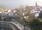
The
villa is inlaid between small hills furrowed by rows of vineyards,
it is center and head of the region of the Ribeiro, one of lines
up them but traditional, productive and better differentiated from
the ourensana province. Ribadavia is capital and heart of ribeiro.
His reduced municipal term of 25.08 km2, one extends throughout
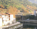
a small séctor of the Miño river, in its right margin,
there where it gathers waters one of its more characteristic affluents,
the Avia, that low of mounts of Airplane.
Sixteen organizations of population and seven parishes compose this
ourensano municipality, located in the noroccidental quadrant and
one of the spaces more densely populated with the province. It has
a rich past, historical mainly artistic, but also he was one of
the more important economic centers of Galicia.It is to 20 minutes
by the A-52 railcar of the ourensana capital and to 35 of the Atlantic
coasts. It is possible also to be acceded by railroad.
Climatically, it has a small suitable microclimate for the culture
of the grapevine. Determined by two factors, the one dryness and
dryness, own of verano y de otra la influences oceánica,
that penetrates |
|